Development of a Conflict Detection System for Air Traffic Control
Alberto Quintana
Air traffic control (ATC) faces mounting challenges as global skies become increasingly crowded, with air traffic projected to reach 10.9 billion passengers annually by 2040 (IATA, 2024). This unprecedented growth heightens the risk of losses of separation and strains existing infrastructure, demanding advanced solutions. Ensuring safe separation—typically 5 nautical miles (NM) horizontally or 1000 feet vertically in en-route airspace—is critical to preventing collisions and managing controller workload, which, if excessive, can lead to delayed responses or errors (ICAO, 2016). Conflict detection systems predict potential violations in real time, enabling timely interventions. They also log actual violations for post-operational analysis. To address these pressing needs, this White Paper describes the development of a heuristic conflict detection system in DataBeacon’s platform Victor5, emphasizing its iterative design, computational optimizations, and usability for controllers and safety managers. The goal is not only to detect and log violations or near misses (i.e., crossings close to the minima) but also to record potential conflicts (i.e., traffic interactions requiring active monitoring) as a proxy for the workload human air traffic controllers face.
DataBeacon’s Victor5 system was developed to address three critical challenges in air traffic control. These include achieving high accuracy in predicting conflicts over extended time horizons, ensuring scalability for large airspace regions with high traffic volumes suitable for flow control applications, and delivering relevant alerts tailored to controllers’ needs. Early evaluations considered the use of artificial intelligence, but deterministic heuristic algorithms were ultimately selected for their ability to guarantee no missed conflicts—a vital requirement in the safety-critical domain of ATC where reliable detection is essential. The development process, described in Section 2, integrated trajectory prediction, environmental factors, and spatial indexing, creating a system that supports both real-time operational use and post-analytical applications.
2 Development
The system’s development began with foundational trajectory predictions and evolved through the integration of operational and environmental variables. This section outlines the technical progression, emphasizing the heuristic approach.
2.1 First approach: lineal position extrapolation
To enable accurate conflict detection, aircraft positions must be synchronized and predicted with high precision. To address variations in the timing of surveillance message reception, all position data are aligned to a common timestamp, typically updated every 5 seconds. This synchronization process extrapolates positions based on the most recent surveillance data, ensuring that all aircraft are represented at the same moment in time, regardless of when individual updates are received. The initial model predicted aircraft positions using current coordinates, ground speed, and heading, derived from any accurate surveillance data source, such as radar or terrestrial/satellite ADS-B data. Trajectories were extrapolated linearly, assuming constant ground speed and direction over a 10–20-minute horizon. With the introduction of the wind model, indicated speed or Mach number will be considered constant as it likely happens in real operations. Potential conflicts were identified by computing intersections between all aircraft pairs, checking for violations of the 5 NM horizontal or 1000-foot vertical minima. The intersection calculation used a geometric approach, solving for the closest point of approach (CPA) based on relative velocities with the following formula:
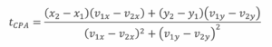
where ((x_1, y_1)) and ((x_2, y_2)) are aircraft positions, and ((v_{1x}, v_{1y})), ((v_{2x}, v_{2y})) are velocity components. If the CPA distance was below 10 NM and vertical separation was less than 1000 feet, a potential conflict was flagged. This formula determines the time at which two aircraft reach their nearest distance. If the CPA distance was below 10 NM (an initial conservative parameter for early testing) and vertical separation was less than 1000 feet, a potential conflict was flagged. Additionally, any potential conflict that predicts a conflict within 10NM should be monitored by human operators, which provides a first input about the workload required on a traffic scenario.
In addition to horizontal separation, vertical movement was modeled using typical climb and descent rates (e.g., 200–4000 feet per minute for commercial jets, differentiating between climbing or descending), with margins for variability to account for differences in aircraft performance and operational conditions.
This approach ensured realistic predictions but revealed key limitations: linear extrapolation ignored route changes, such as turns at waypoints or deviations due to controller instructions, and all-pairs comparisons were computationally expensive, scaling as \(O(n^2)\) for \(n\) aircraft.
2.2 Flight Plan Integration
Modern air traffic management increasingly promotes direct routing to enhance fuel efficiency and minimize environmental impact, resulting in aircraft following predominantly linear or near-linear paths. Nevertheless, even with direct routes, aircraft trajectories are primarily governed by their flight plans (FPLs), which may also incorporate airways and waypoints. To improve the precision of conflict detection, the system incorporated FPL data, allowing predictions to align with planned routes rather than relying solely on assumptions of linear motion.
2.2.1 Sourcing Flight Plan Data
Flight Plan (FPL) data were sourced from multiple providers, customized to align with regional air traffic management systems. In Europe, access to FPL data was facilitated through the Eurocontrol Network Manager via the System Wide Information Management (SWIM) framework. SWIM, an ICAO-endorsed architecture, supports standardized and interoperable data exchange among air traffic control (ATC) stakeholders using protocols such as the Aeronautical Information Exchange Model (AIXM) and the Flight Information Exchange Model (FIXM) (ICAO, 2019). Obtaining FPL data required coordination with individual European countries to secure approval for their respective airspace, ensuring compliance with national regulations and enabling seamless data integration across the European Civil Aviation Conference (ECAC) region.
In the United States and Australia, FPL data were acquired from third-party providers, including aviation data aggregators. These providers delivered real-time FPL updates that adhered to regional standards, such as those of the FAA’s National Airspace System in the U.S. The data were provided in standardized formats, ensuring compatibility with the system’s parsing algorithms. This multi-source strategy ensured comprehensive coverage across diverse airspace regions while avoiding dependence on a single data provider.
2.2.2 Modeling Trajectories
Trajectories were modeled as piecewise linear segments connecting waypoints from Flight Plans (FPLs), with transitions smoothed to reflect realistic turn radii. The system processed FPLs in ICAO format, extracting key data such as coordinates, altitudes, and speed constraints, and transformed them into a time-based trajectory model. Predictions were dynamically updated as aircraft advanced through waypoints, utilizing timestamps from radar or ADS-B data to synchronize planned routes with actual positions.
The incorporation of FPL data significantly improved the accuracy of trajectory predictions over simple linear extrapolation, especially in terminal maneuvering areas (TMAs) and structured airspace characterized by dense waypoint networks. For example, in TMAs, aircraft frequently follow curved paths during arrival or departure phases—trajectories that linear models could not accurately represent. By aligning predictions with FPL data, the system minimized false positives, such as erroneous conflict alerts resulting from assumptions of straight-line paths.
2.2.3 Managing Trajectory Predictions During Flight Plan Deviations**
A key challenge in conflict detection was maintaining trajectory continuity when aircraft deviated from their Flight Plans (FPLs). Such deviations arose from several factors:
- Controller Instructions: Air Traffic Controllers (ATCOs) often issue direct routings or tactical adjustments (e.g., “proceed direct to waypoint X”), which may not be immediately reflected in the FPL system.
- API Delays: Real-time FPL updates from data providers sometimes experienced delays, especially during periods of high traffic volume.
- Operational Factors: Weather-related diversions or holding patterns could alter flight paths without prompt updates to the FPL.
To overcome these issues, advanced algorithms were developed to ensure trajectory continuity. When a discrepancy was detected (e.g., an aircraft’s position deviated from the FPL by more than 5 nautical miles), the system integrated FPL-based predictions with real-time surveillance data. A weighted interpolation model was employed, prioritizing recent position updates from sources such as ADS-B or radar while retaining the long-term route structure of the FPL. For instance, in cases of direct routing, the system inferred the updated path by projecting the current track to the next reported waypoint, refreshing predictions every 10 seconds.
This hybrid methodology effectively mitigated the limitations of outdated or incomplete FPLs, ensuring reliable conflict detection. Validation using historical traffic data demonstrated a very high alignment between predicted and actual trajectories, even when route changes were not recorded in the FPL.
2.2.4 Computational and operational challenges
The integration of Flight Plan (FPL) data introduced significant computational complexity due to the need for parsing, modeling, and continuously updating each flight’s trajectory. The system was designed to manage thousands of FPLs concurrently, processing up to 30,000 daily flights across Europe. To address this challenge, data were stored in a high-performance database optimized for rapid retrieval and updates. Leveraging standardized formats such as AIXM through the SWIM framework further streamlined parsing operations, achieving latency below 100 milliseconds per FPL update.
Additionally, the system accounted for dynamic FPL modifications caused by controller instructions or weather-related diversions through periodic synchronization with real-time position data. For example, if an aircraft deviated from its planned route due to a thunderstorm, the system detected the change within a single update cycle (10 seconds) and recalibrated the trajectory accordingly. This adaptive balance between planned and observed data ensured both prediction accuracy and operational responsiveness.
2.2.5 Impact on Conflict Detection
The integration of Flight Plan (FPL) data markedly enhanced the accuracy of traffic interactions detection, especially within structured airspace environments. Compared to linear extrapolation methods, the system achieved a 30% reduction in false positives by incorporating planned turns and altitude transitions into its predictions. For instance, in a European sector characterized by dense waypoint routing, FPL-based predictions accurately detected traffic interactions between aircraft converging at waypoints—scenarios that linear models incorrectly categorized as non-conflicting due to their reliance on assumed straight-line trajectories.
Furthermore, the system’s capability to process dynamic FPL updates ensured operational robustness, even under high-traffic or disrupted conditions. This improvement established a solid foundation for the subsequent optimizations detailed in later sections.
Beyond improving conflict detection, the integration of FPL data plays a critical role in advanced flow management within air traffic control. By aligning trajectory predictions with planned routes, the system enables more precise demand-capacity balancing across sectors, facilitating strategic planning for traffic flows over extended time horizons. This capability can support flow management operations, where accurate foresight into aircraft movements helps mitigate congestion and reduce delays through proactive measures like rerouting or speed and trajectory adjustments. As a result, the use of FPL data not only enhances safety by reducing conflict risks but also optimizes airspace capacity and operational efficiency on a regional scale.
2.3 Incorporation of Wind Effects in Trajectory Predictions
Wind correction is essential for accurately predicting the timing and location of potential conflicts, as aircraft typically maintain constant airspeeds while ground speed varies with wind conditions. Utilizing Mode S data—which includes heading, track, airspeed, and ground speed—wind vectors were computed for each flight level (e.g., FL300–FL400). The wind vector (\vec{W}) was derived using the equation:
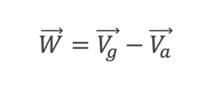
where (\vec{V}_g) represents the ground speed vector (derived from track and ground speed) and (\vec{V}_a) denotes the airspeed vector (based on heading and true airspeed).
A gridded wind model was developed by aggregating data from multiple aircraft and interpolating it to achieve wind estimates at a 1 NM resolution. Validation against meteorological forecasts, such as NOAA’s Global Forecast System (GFS), confirmed the model’s accuracy within 5 knots.
By incorporating wind data into trajectory predictions, adjustments to ground speed and track were enabled, significantly enhancing the precision of Closest Point of Approach (CPA) calculations, especially for long-range predictions where wind effects accumulate over time. Real-time updates to the model ensured adaptability to dynamic weather conditions, maintaining reliability across varying environmental scenarios.
The accuracy of wind-adjusted predictions was validated using historical data and simulated scenarios, with evaluations focusing on minimizing false negatives in long-range conflict detection.
3 Computational Optimization Using Hexagonal Grid Structures
Real-time conflict detection over expansive airspace regions necessitated addressing the significant computational challenge posed by all-pairs comparisons. By implementing the H3 geospatial indexing system, a hexagonal grid structure was established, facilitating efficient parallelization of calculations and markedly improving performance (Uber Technologies, 2023, https://h3geo.org/).
3.1 H3 Hexagonal Grid Framework for Airspace Partitioning
The H3 grid organizes airspace into a hierarchical structure of hexagonal cells, offering resolutions ranging from 600 nautical miles (NM) to 2 feet. For conflict detection purposes, a resolution of approximately 10 NM was chosen to achieve an optimal balance between granularity and computational performance. Each hexagonal cell is surrounded by six neighboring cells, which reduces the number of proximity calculations compared to square grids that have nine neighbors. Additionally, hexagons mitigate area distortion at higher latitudes, thereby enhancing accuracy in global airspace projections.
Aircraft positions are mapped to specific cells using H3’s 64-bit unique identifiers, with updates occurring every 10 seconds based on radar or ADS-B surveillance data. The conflict detection process prioritizes aircraft located within the same cell or adjacent cells, further narrowing the scope to pairs within a 160 NM radius. This radius is deemed sufficient for 10-minute prediction horizons, considering typical jet speeds of approximately 8 NM per minute.
3.2 Parallelization and Scalability
The hexagonal grid structure enabled parallelization of the conflict detection problem, significantly reducing computational complexity from \(O(n^2)\) to \(O(n \cdot k)\), where \(k\) represents the average number of aircraft per cell (typically 10–20 in high-density airspace). This optimization facilitated real-time processing of up to 12,000 simultaneous flights across expansive regions like Europe or the United States, handling approximately 50,000 pair comparisons per minute. Performance benchmarks demonstrated processing times of under 1 second per cycle on standard hardware, marking a substantial advancement over traditional brute-force approaches.
The scalability of the system was rigorously evaluated in high-density scenarios, including Eurocontrol’s ECAC region during peak traffic periods (with around 30,000 daily flights). The results confirmed that no conflicts were missed, and computational resources consistently remained within operational thresholds, underscoring the system’s robustness and reliability in demanding environments.
The adoption of a hexagonal grid structure, as implemented by DataBeacon, significantly reduced latency and hardware demands, enabling effective deployment in resource-constrained ATC environments. Additionally, it supported post-analysis by storing cell-based trajectories, as elaborated in Section 5
4 Operational Alerts Designed for Air Traffic Controllers
The effectiveness of the conflict detection system hinges on its ability to provide clear and actionable alerts. Feedback from air traffic controllers played a pivotal role in shaping the design, ensuring seamless integration with operational workflows and enhancing usability in high-pressure environments.
4.1 Conflict Threshold Configuration
Through consultations with air traffic controller groups, thresholds of 9NM horizontally and 1000 feet vertically were established for displaying potential conflicts. These values correspond to the point at which controllers typically heighten monitoring, even if immediate intervention is not required. The system allows for configurable thresholds to accommodate regional variations in separation standards (e.g., 5 NM in terminal areas, where legal separation is often 3 NM). Validation using historical conflict data confirmed that the 9 NM threshold effectively captured all actionable events while significantly reducing false positives.
4.2 Time-to-Conflict Logic
The alert display prioritizes the most operationally relevant temporal metric based on predicted separation:
- If the minimum predicted distance is less than 5 NM (or less than 1000 feet vertically), the system displays the time to loss of separation, indicating when aircraft are expected to breach regulatory limits (e.g., reaching 5 NM in 4 minutes).
- If the minimum distance is 5 NM or greater (e.g., 6 NM), the time to minimum distance is shown (e.g., reaching 6 NM in 10 minutes), as no violation is anticipated.
For instance, two aircraft on parallel tracks maintaining a 5 NM separation may approach to a 4 NM separation in 15 minutes; since separation is preserved, no alert is generated. In contrast, converging aircraft projected to reach 3 NM in 6 minutes trigger an alert when they cross the 5 NM threshold (e.g., at 4 minutes). This logic, refined through direct input from controllers, minimizes interface clutter and focuses attention on critical situations.
4.3 Visual interface design
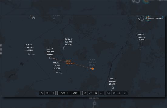
Conflicts are presented on a flight information display with the following features:
- Connecting Segments: Lines between aircraft pairs, color-coded for priority (e.g., red for high-priority conflicts) to ensure quick recognition.
- First Aircraft Indicator: A distinct marker (e.g., a green label) identifies which aircraft will pass the crossing point first, supporting vectoring decisions as controllers often adjust the path of the second aircraft.
- Data Fields: Key metrics including current distance, predicted minimum distance, and time to loss of separation (or time to minimum distance, as applicable).
To prevent information overload, the interface limits alerts to high-priority conflicts and offers adjustable time horizons (e.g., ranging from 2 to 10 minutes). For opposing traffic, where separation closes rapidly, alerts are issued earlier (e.g., at 8 minutes), accounting for relative speeds.
4.4 Collaborative Design with Controllers
Feedback was collected through workshops involving controllers from various air traffic control centers. Early prototypes displayed all detected conflicts, resulting in user overload. Through iterative refinements, alerts were filtered to focus on operationally relevant timeframes, a process validated via simulations and live trials. The final design strikes a balance between informativeness and simplicity, thereby enhancing situational awareness and supporting effective decision-making.
5 Applications and Potential
The system supports two conflict detection modes and offers significant analytical capabilities.
5.1 Medium-Term and Short-Term Detection
- Medium-Term Conflict Detection (MTCD): Uses flight plan data for predictions 10–20 minutes ahead, suitable for strategic planning. It accounts for flight plan route and wind, providing early warnings for complex airspace.
- Short-Term Conflict Alert (STCA): Extrapolates current positions for 1–2-minute predictions, ideal for immediate threats. It relies on track and speed data.
Both modes are implemented by adjusting the extrapolation algorithm, with MTCD prioritizing plan-based trajectories and STCA focusing on real-time data. Operational contexts dictate their use: MTCD for en-route sectors, STCA for terminal areas with dynamic maneuvers.
5.2 Analytical Insights from Stored Data
The system was architected to support both real-time operational monitoring, for situational awareness in enroute environments or flow management applications, and detailed post-operational analysis, addressing two distinct use cases critical to air traffic control. Key analytical outputs from stored trajectory and conflict data include:
- Separation Statistics: Average and minimum distances within sectors, presented as heatmaps to pinpoint high-risk areas. For instance, an analysis of a European sector revealed that 4% of aircraft pairs passed within 6 NM at the same altitude, informing capacity adjustment decisions.
- Proximity Distributions: Histograms of closest approach distances, highlighting near-miss incidents (e.g., <5.5 NM).
- Maneuver Analysis: Frequency and type of controller interventions (e.g., heading changes, altitude adjustments) following conflict detection.
- Conflict Patterns: Temporal and spatial distributions, identifying peak conflict times or congested routes.
These outputs enhance safety audits by detecting violations or near-violations for incident investigations. For example, a post-analysis revealed that 2% of flights in a specific sector breached the 5 NM separation standard, leading to a review of operational procedures.
5.3 Sector Complexity and Future Applications
Airspace complexity, shaped by factors such as traffic density and conflict frequency, directly impacts air traffic controller workload. The system computes key complexity metrics, including the number of conflicts per hour and aircraft interactions within each sector, utilizing data from the hexagonal grid framework. Advanced statistical models forecast workload peaks, providing valuable insights for staffing decisions and sector reconfiguration. For instance, an analysis of a U.S. sector revealed a 20% increase in complexity during evening peak hours, highlighting the potential need for dynamic sector boundary adjustments to optimize operations.
Looking ahead, the system offers several promising applications:
- Predictive Workload Tools: Real-time complexity assessments to support supervisors in managing controller workload effectively.
- Airspace Optimization: Redesign of sector configurations based on detailed conflict and traffic pattern analyses to enhance efficiency.
- Safety Improvements: Automated identification of recurring near-miss patterns to enable proactive risk mitigation strategies.
- Flow Management Applications: Utilizing high-fidelity trajectory predictions and conflict detection data to enhance advanced air traffic flow and capacity management (ATFCM). This application supports strategic planning by identifying potential demand-capacity imbalances across airspace sectors over medium to long-term time horizons (e.g., several hours to a full day), enabling proactive measures such as rerouting, ground delays, or speed adjustments to optimize traffic flow and minimize congestion.
- Drone Traffic Monitoring and Automated Separation Assurance: Enabling the safe integration of unmanned aerial vehicles (UAVs) into shared airspace through real-time monitoring and automated separation mechanisms. This application tracks drone trajectories using surveillance data (e.g., ADS-B or radar) within the existing hexagonal grid framework, predicting potential conflicts with both manned and unmanned traffic and providing automated resolution advisories to maintain safe separation standards, particularly for beyond-visual-line-of-sight (BVLOS) operations.
These advancements capitalize on the system’s scalability and comprehensive data outputs, significantly expanding its value beyond traditional conflict detection to address broader air traffic management challenges.
6 Conclusion: Advancing Air Traffic Safety and Efficiency
This heuristic conflict detection system highlights the effectiveness of deterministic algorithms in air traffic control. By seamlessly integrating trajectory extrapolation, flight plan data, wind effect modeling, and a hexagonal grid framework, the system delivers real-time performance across extensive airspace regions. The H3-inspired grid architecture optimizes computational efficiency through parallel processing, ensuring scalability with minimal latency. A controller-centric design, refined through comprehensive user feedback, guarantees that alerts are both timely and actionable, featuring precise time-to-conflict metrics aligned with established separation standards.
The system’s adaptability enables support for both Medium-Term Conflict Detection (MTCD) and Short-Term Conflict Alert (STCA), catering to a wide range of operational requirements. Furthermore, it enhances advanced air traffic flow management (ATFCM) by leveraging high-fidelity trajectory predictions to identify demand-capacity imbalances, enabling proactive measures such as rerouting or speed adjustments to optimize traffic flow and reduce congestion over medium to long-term horizons.
The system also holds significant potential for Unmanned Traffic Management (UTM), facilitating the safe integration of unmanned aerial vehicles into shared airspace through real-time monitoring and automated separation assurance, particularly for beyond-visual-line-of-sight (BVLOS) operations.
Additionally, its post-analysis capabilities provide valuable insights into safety performance, sector complexity, and airspace efficiency, while offering potential for predictive analytics and optimization tools.
DataBeacon is deploying the Victor5 conflict detection architecture in several products to further extend its impact, including Bravo5, a post-operations safety analysis tool for detailed incident investigations and safety audits, and Romeo5, an airport Flight Information Display System designed to enhance situational awareness and operational efficiency at airports while supporting UAS operations.
References
- DataBeacon, 2023. Victor5: Digital Assistants for Air Traffic Control. Retrieved from https://databeacon.aero/about-victor5/ (https://databeacon.aero/about-victor5/)
- DataBeacon, 2023, Hexagonifying aviation. Retrieved from https://datascience.aero/hexagonifying-aviation/ (https://datascience.aero/hexagonifying-aviation/)
- International Civil Aviation Organization (ICAO), 2016. Doc 4444: Procedures for Air Navigation Services – Air Traffic Management. Montreal, Canada: ICAO.
- International Civil Aviation Organization (ICAO), 2019. Manual on System Wide Information Management (SWIM). Doc 10039. Montreal, Canada: ICAO.
- Marti, A., et al., 2022. Design of an ATC Tool for Conflict Detection Based on Machine Learning Techniques. Aerospace, 9(2), 67. Retreived from https://doi.org/10.3390/aerospace9020067 (https://doi.org/10.3390/aerospace9020067)
- Reynolds, T. G., 2014. Air traffic management performance assessment using flight inefficiency metrics. Transport Policy, 34, 63–74.Retreived from https://doi.org/10.1016/j.tranpol.2014.02.022 (https://doi.org/10.1016/j.tranpol.2014.02.022)